4/23/2010

Maya: Converting a 3d-mesh to a Heightfield, Part 1

This tutorial walks through the process of sculpting a basic 3d terrain in Maya with the Mesh>Sculpt Geometry Tool, and then the process of creating a 2d greyscale height-map from that object. We will then import that object into L3DT as a design map and run it through the terrain algorithms to generate a detailed height-map that has cliffs, erosion effects, climate-map layouts, and procedural textures applied.

Details are under each image:


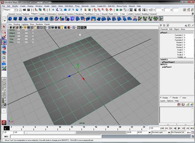
In step one, I have crated a poly plane that is 10 maya units by 10 maya units, and has 10x10 subdivisions. I have also created a point light (and moved it a little to one side), and also turned surfaces and lighting on (this helps in sculpting).


8 Things You Should Know About Concentrating

http://howtogetfocused.com/chapters/8-things-everybody-ought-to-know-about-concentrating/

This is a really good selection from the author's book, and include things everyone should read, integrate, and be able to express in their own terms. The pic in the article is well done CG as well:


I have a few things to post in the near future, starting with a quick Maya tutorial about converting a 3d-mesh poly terrain to a 2d greyscale height-map. Many game engines and 3d tools like L3DT use height-maps as the base for push/pull and scultping tools. This question came up on the Bundysoft L3DT forums (http://www.bundysoft.com/phpBB2/viewtopic.php?t=1472) and it seems a visual tutorial would be a great resource.